See other Science/Tech Articles
Title: NASA maps summer melt of Greenland Ice Sheet
Source:
[None]
URL Source: https://www.upi.com/Science_News/20 ... nland-Ice-Sheet/7001504898809/
Published: Sep 8, 2017
Author: Amy Wallace
Post Date: 2017-09-09 09:15:17 by BTP Holdings
Keywords: None
Views: 250
Comments: 5
NASA maps summer melt of Greenland Ice Sheet The mission of Operation IceBridge, NASA's longest-running airborne mission to monitor polar ice, is to collect data on changing polar land and sea ice. By Amy Wallace | Sept. 8, 2017 at 4:24 PM Terminus of the Zachariæ Isstrøm glacier in northeast Greenland, as seen from 28,000 feet during an Operation IceBridge flight on Aug. 29, 2017. Photo courtesy NASA/LVIS Team Sept. 8 (UPI) -- NASA's Operation IceBridge has been mapping summer ice melt of the Greenland Ice Sheet since Aug. 25 using a B200T King Air aircraft. The flights will go through Sept. 21, with repeat paths to be flown in the spring to monitor seasonal changes in the elevation of the ice sheet. "We started to mount these summer campaigns on a regular basis two years ago," Joe MacGregor, IceBridge's deputy project scientist and a glaciologist with NASA's Goddard Space Flight Center in Greenbelt, Maryland, said in a press release. "If the flights go as expected, the result will be a high-quality survey of some of the fastest melting areas in Greenland and across as much of the island as possible." For the campaign, Operation IceBridge is flying a B200T King Air from Dynamic Aviation carrying the Land, Vegetation and Ice Sensor, a laser instrument built by Goddard that measures changes in the ice elevation with an accuracy of 4 inches or better and a high-resolution camera system to map the ice surface. "For this campaign, we're mapping as broad an area as possible, because we want to understand the seasonal cycle of elevation change across the entire ice sheet," MacGregor said. "When NASA's Ice, Cloud, and land Elevation Satellite-2 [ICESat-2] mission is up and running next year, it'll be mapping these changes continuously. We need to better understand the magnitude of seasonal elevation change between the spring and the summer right now so that we have a starting point from which to evaluate any trend observed by ICESat-2." Some of the images show the calving front -- the end of the glacier where it sheds chunks of ice -- of the Zachariæ Isstrøm glacier in northeast Greenland. The IceBridge team moved to Kangerlussuaq, in central western Greenland on Sept. 1, from where they plan to fly over fast-changing areas such as Jakobshavn Isbræ and Helheim Glacier. Their goal is to accomplish 16 flights in total during the campaign. Poster Comment: Take it for what it's worth.
Post Comment Private Reply Ignore Thread
Top • Page Up • Full Thread • Page Down • Bottom/Latest
Begin Trace Mode for Comment # 2.
#2. To: BTP Holdings (#0)
Formation of the Great Lakes - YouTube, 1.25 minutes
#3. To: GreyLmist (#2)
Satellite shows Greenland's ice sheets getting thicker All down to more snow falling, it seems While the edges of the glaciers are melting, the ice sheets in Greenland's interior are getting thicker, according to satellite data collected over the last 11 years. On average the ice sheets have got thicker by about six centimetres each year, the researchers say. The researchers, based at Norway's Nansen Environmental and Remote Sensing Center (NERSC), say that this is probably because snowfall in the region has increased, due to a weather pattern known as the North Atlantic Oscillation (NAO). The research was conducted using the European Space Agency's ERS satellites. These carry radar altimeters that send 1800 radar pulses to Earth each second, and record how long they take to return to the satellite. The sensor can time this journey down to the nanosecond, ESA says, meaning that the instrument is accurate to within two centimetres. In total tens of millions of data points were collected. The results were then compared to the known fluctuations in the NAO over the period. The researchers found a strong relationship between changes in the height of the ice sheet and the strong positive and negative phases of the NAO. Professor Ola Johannessen of NERSC says that the results suggest that the role of the NAO in ice thickness is more significant than previously thought, making it something of a wildcard in climate modelling.
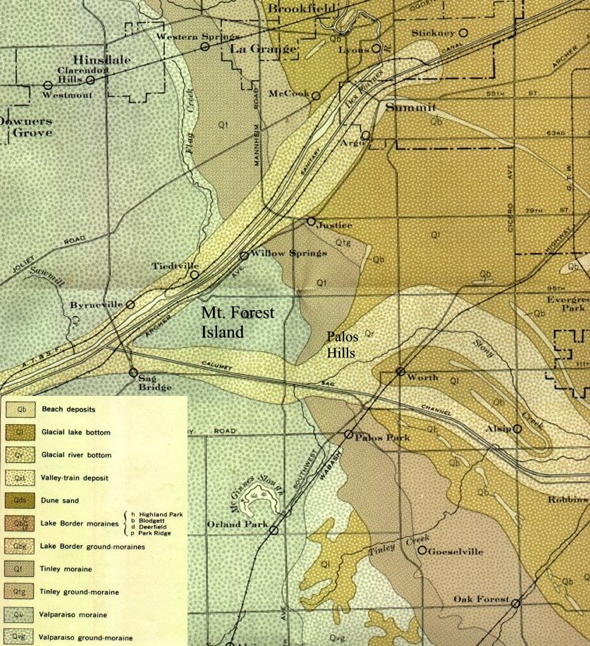
Thanks for the video about the Great Lakes. Of course since I am from Chicago I am astutely familiar with the geology of that area, especially since I was a rock hound when younger. Here is a map of the Sag in southwest suburban Chicago. The Sanitary and Ship Canal was dug thru it to reverse the flow of Chicago River.
Top • Page Up • Full Thread • Page Down • Bottom/Latest
Replies to Comment # 2.
By Lucy Sherriff 7 Nov 2005 at 16:46 SHARE ▼
#5. To: GreyLmist (#2)
End Trace Mode for Comment # 2.